

Between May and October, visitors are required to have reservations to visit Ape Cave. This is in order to help protect the delicate cave ecosystem. Visitors are required to have one reservation per vehicle that your group is taking to the trailhead. Make reservations at recreation.gov.
The full experience at Ape Cave includes the easy exploration of a spacious lava tube, followed by more difficult travel through a smaller, longer, and more rugged lava tube to an exit. Then, enjoy an easy return hike winding through shady forest and crusty lava formations.
Before you go, make sure everyone in your party is aware of the restrictions and conditions: No food, pets, smoking, or rock collecting. Do not touch the walls, which harbor cave “slime”, a food source in the cave’s delicate ecosystem. The temperature is a constant 42 degrees F. The ceilings are drippy, and there may be puddles. Bring 2 or 3 light sources and spare batteries. No cave can ever be considered completely safe.
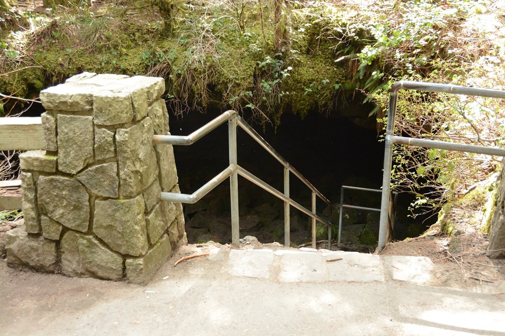
A short distance from the parking lot, enter the large cave entrance and descend two staircases to the floor of the cave and the signed junction between Upper and Lower. The data listed above for mileage and elevation gain exclude the lower cave, combining only the upper cave and the return trail. You may find that you hike more miles if you explore the Lower Cave as well.
Head into the Upper Cave. It's a 1.5 rugged miles one way, requiring significantly more time, caution, and some physical agility. It is a more interesting route though, with the lava tube shape, size, and geology changing frequently. Not far from the staircase, the passage encounters its first of many rock piles. You must climb up, over, or around the abrasive rocks, taking care not to twist an ankle or, in some places, bump your head.
At about 0.8 mile is the narrowest part of the passage, and the crux move: a slick, wet, 8-foot lava fall. Some people need assistance scaling it, as there is only one significant foothold.
Beyond the lava fall are a couple of rock formations that require some physical ability to climb over or to squeeze around. Then at about 1.2 miles is the Skylight, a hole in the ceiling which allows in the first natural light since the entrance. The Skylight is neither a safe nor legal exit.
The affixed metal ladder at about 1.4 miles is the Upper Entrance, and your exit. You may choose to continue the final 500 feet beyond to the natural end of the lava tube. The ceiling is only about 6 feet high in places, so take care. Then retrace your steps to the ladder and head up topside.
The return trail is marked for travel in snow. Simply follow the blue diamond markers affixed high on tree trunks. When snow not present, keep an eye out for other small caves and pockmarks in the rough lava. The trail drops gently the 1.3 miles back to the Main Entrance.
If the Upper Cave is a bit too rugged for you, consider exploring the Lower Cave. It's a broad lava tube that descends gently to its end. The floor is flat (though a bit uneven at first), then sandy later on, from a mud flow that filled the lower portion centuries ago. The end of the cave now is where the sand has filled in to within a couple feet of the ceiling. The Lower Cave is an easy walk, for a 1.5 mile round trip, that houses a popular geologic anomaly known as the Meatball.
Note: Some people hike the trail uphill, then enter the cave via the Upper Entrance. There are two concerns about this: Firstly, the lava fall is easier to ascend than to descend safely. Additionally, from the main entrance, you immediately experience climbing over and around rock piles, enabling you to decide whether the Upper Cave is more than you wish to attempt.
WTA Pro Tip: At 13,042 feet long (about 2.4 miles), Ape Cave is the third longest lava tube in North America. It is sometimes referred to as Ape Caves (plural) because the main entrance is between its two ends, referred to as the Lower Cave and Upper Cave.
Ape Cave was formed nearly 2000 years ago from lava streaming down the southern flank of Mount St. Helens. As the outer edges cooled into a hardened crust, the inner molten lava was able to drain away before it hardened, leaving behind a tube. After stumbling upon the cave in approximately 1950, a logger told his spelunker friend. That friend explored the cave with his sons and their friends, who called themselves the Mount St. Helens Apes. Thus the name of the cave.

 Trailhead


